6 April 2017
Mount Wellington looms above Hobart, impenetrable, formidable, smug. I head off into traffic – Hobart traffic seems like no other; it happens in fits and starts, peak hour traffic lights that hold on red for too long, busy but that is a matter of perspective…
As a cyclist in a different place, I lack the surety of knowledge of traffic that I know from home. I always need a map to give a layout, an orientation of where I am. I nudge my way into the left lane as I head up Davey Street – supposedly the A6 highway – five lanes of one-way traffic. I know that I will need to head over a couple of blocks north to make it out of town but exactly how is a little vague, despite studying Google maps for a route. I assert myself in the traffic a little more as cars bank up – I fly by cars and trucks; lots of trucks, noisy and aggressive and another cyclist – and hit a rise in the street. A glimpse of the mountain and it is a huge backdrop to the scene – I’m not sure how other cyclists feel, but I always wonder if I will be able to make it up such inclines, if my legs will actually be able to turn over enough times to get to the top. Then rationality kicks in – I’ve climbed such suckers before, such mocking mountains. Or, at any rate, I managed to make it up a couple of big hills already.
I’m looking for any sign of a turn off to the Cascade Brewery – I know I need to head towards there to begin the official Strava Mount Wellington climb, but the uncertainty of one way streets is a little disconcerting. Cascade Rd becomes Strickland Ave just past the brewery and this is the start of the climb. Someone sounds their horn. I’m relieved that it doesn’t seem to be directed at me. Still, I’m meandering a little in my quest for a north-west passage. I find the turn off – the northern end of what is known as the Southern Outlet – but everyone seems to be turning left and I’m in the left lane wanting to head to the right. I flail my arm as I see a gap having seen the trucks earlier, I suspect that imitating their aggression is the best option – I opt out of the noisy part, nonetheless. It seems to work or at least some poor motorist takes pity on this humble cyclist pretending to be a massive truck, veering to the right. I stop at the traffic lights to turn right.
The slip road down to Macquarie St is easy and, before I know it, I’m heading along a quiet main street that becomes Cascade Rd. I pay a bit more attention to the music I’m listening to – I find that I gain rhythm from music, such that it seems to regulate a good pace and I reach the brewery – a lovely quaint building, sandy in colour with highlighted window frames. There’s a slight musty-alcoholic smell – nice but not overpowering. Of course, the brewery is not just this building, but I like the look of this building and it gives me a sense that if people originally made beer in this building then they must know what they’re doing. Not really sure of that logic, how a building gives a sense of something, but I think it does. And anyway, when cycling these insights are potentially flawed. I cycle on, officially starting the Strava climb…
The slope starts to assert itself – Strickland Ave is quite a reasonable entry point in terms of incline. Houses are tucked away in little nooks and crannies – I wonder where that saying came from? – I get ‘nooks’, but not sure where ‘crannies’ began. Did someone once have a ‘crannie’ (or was that a ‘cranny’) to stash stuff? And what do you stuff in a crannie? Sounds a bit like something the Scottish invented, laddie! There seems to be roadwork wherever anyone goes and this is no different, so I wave to the guy on stop-sign duty and with a ‘hey, mate’ (standard riding vernacular) get out of the saddle and push on. All of a sudden a guy rides up behind me and overtakes – he’s on a mountain bike, dressed in bright yellow. I’m amazed at his speed – now it is worth reflecting on the fact that cycling is the great humbling pastime because there is always someone who passes you that has gone further or faster than you. Just when you get a bit ‘cocky’ because you flew by two part-time cyclists who would be 80 or so, bang!!!, someone flies past you doing twice your speed up a hill! Anyway, the guy in yellow – must be a TdF winner, given his speed and colour – turns into what I imagine is his home. My confidence returns – surely he’s only on a Oh-I-Just-Nipped-Out-To-Grab-Some-Milk-From-The-Corner-Shop-Kinda-ride. I reach the Huon Rd intersection – nearly at the Mt Wellington climb proper.
The road flattens out before I reach the Pinnacle Rd right-hand turn. A sign tells me that I’m in Fern Tree – of course, my mind wanders to the fact that there must be a gully around here somewhere that someone could call Fern Tree gully, which is what probably happened in Melbourne. But I can’t see any gullies and that is quite a pointless thing to consider anyway, so I forget that thought and focus on the right turn. All of a sudden, cars materialise – cars are everywhere and, just to add a chaotic mix, there’s a bus. What is it about intersections? And while we are considering these bizarre phenomenal occurrences, how it is that there can be two cars on a road going in opposite directions and they cross right where a cyclist is riding? Getting back to my original dilemma, an observation – intersections attract traffic. I do my truck impersonation again and assert myself with a flailing arm that blinks ‘turning right’ and I begin the ascent.
I like this mountain. The beginning is quite a relaxed incline – seems a little like my home climb, the 1:20 from The Basin to Sassafras. And – big plus here – there is ‘official’ signage on the road surface to indicate how far to go. This is great, since my Garmin is off for repairs. Twelve kilometres to the summit; yep, I reckon I can do that. The scenery is beautiful, magical, a mixture of rainforest and bush, although there isn’t really a view at this level due to the thicker tree coverage. The road is not so magical – uneven, a little battered from constant drips of rainwater, small mounds made by subsequent repairs, potholes caused by subsequent repairs. I remind myself that cyclists are tough – a little corrugation never stopped cyclists summiting Mt Wellington…they are a bit bumpy though…particularly when I’m seriously trying to establish a rhythm…I round the first major bend.
I come to a false flat – false flats are great. Pretty much any time when you feel things get easier are great. I pick up speed, conscious that my overall average could do with a boost right about now and am able to feel like I’m going flat or even slightly downhill. This lasts for about a good kilometre or so and I round another bend and come past a sign for Lost Freight. This doesn’t seem to make much sense until I pass the café in a shipping container, apparently built on the site of a historic chalet that was burnt down in the 1967 fires. A coffee right about now would be ideal – I haven’t had a coffee yet this morning. But I resist – maybe on the way down? Onwards and upwards…I’ve only completed about four or five kilometres.
The full extent of the seriousness of this climb hits at pretty much right on seven kilometres to go. The incline increases to what I think is about 9 percent. I feel pretty good, particularly after the false flat and the civilised potential of coffee, but doubt – always that masterful psychological manipulator – kicks in. This is where the signage on the road is not necessarily that helpful – what if I still have seven kilometres to go at this gradient? How long is that going to take me? I start mentally calculating, which is not easy for me at the best of times…that’s seven or so kilometres…even if I do about ten kms an hour…that’s another forty-five mins or so…but what if I can only do five kms? What if the gradient increases? That’s another hour and an half! So I choose not to calculate and just keep turning pedals instead.
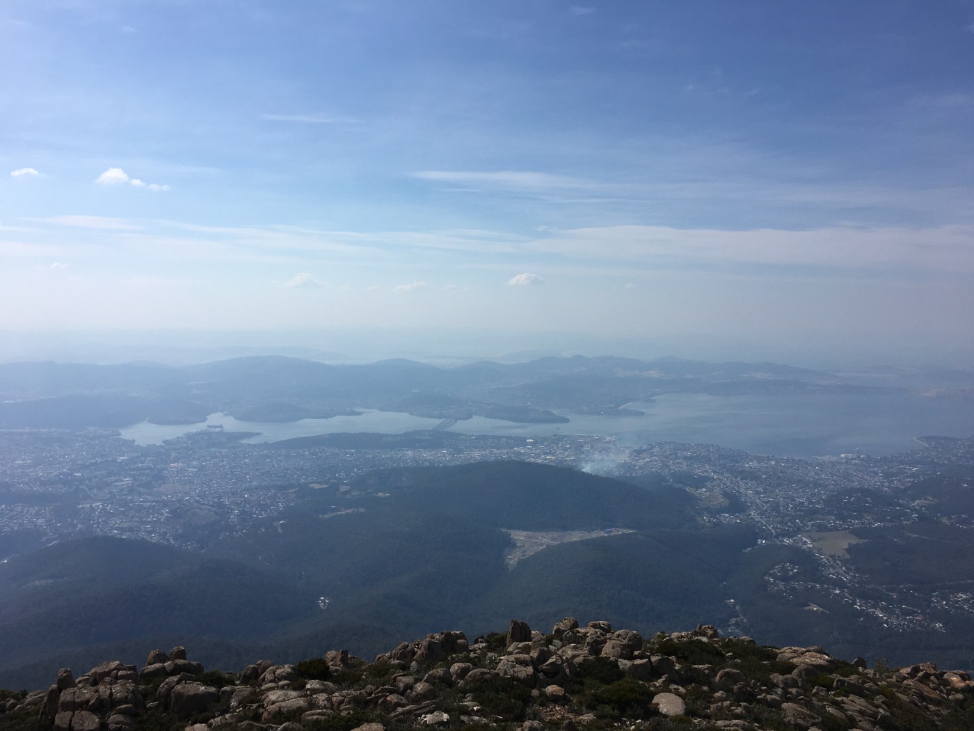
As the road cuts back into the mountain, it traverses north and rises steadily. I emerge slowly from the trees and get the first view, sporadically interspersed with trees and brush, looking south towards Sandy Bay – it is quite breathtaking. One of those views that has mountains fading to different blues and greys in the background for as far as my eyes, with sweat dripping into them, can see. My, I think or maybe I say – it is hard to tell what is spoken and thought right now – I am up high! The view is splendid and I wonder if others passing in cars get to see such a view – the trees interfere with an uninterrupted view. But the road is rough and narrow and steep and for a cyclist doing about ten kilometres an hour, it is good to be careful. Besides, it is time to grind away at the slope now – head down, legs are beginning to burn a little.
Long stretches of uphill. Constantly high gradient. Wondering if the next bend will give some relief. Except there are no bends. Finally, it seems I leave the southern view and head into the ridge of the mountain, still about four (or is it five) kilometres to go. The terrain has changed; granite rock has emerged as the major backdrop, brown-green brush rather than trees, but the view is still magnificent – the Derwent River winding, snaking back into the countryside. The hills in the distance, looking towards Bridgewater and beyond, look dry and burnt. It seems like it has been a hot summer with little rain.
The road starts to widen a bit and I encounter some cyclists coming down the mountain. I think these are from the cars and busses that passed me earlier – tours that take people to the top and they can ride down. At the moment this seems like a promising option, something Kaye would definitely prefer. It buoys me somewhat and I give a series of nods and ‘hey mates’ to those coming down, all in orange vests, all happily rugged up because of the cool wind, all sitting in their saddles, seemingly free-wheeling, a contrast to my overheating body in pink Rapha top and pedalling, turning, out of the saddle, burning legs. In hindsight and in consultation with Kaye later, who met me after driving to the top, it sees that memories are quite subjective things. In contrast to my ‘Sound-Of-Music-Hills-Are-Alive’ flowery memories of free-wheeling down the mountain without a care in the world, these riders, from Kaye’s perspective seemed to be cautiously, anxiously, eternally squeezing hands on brakes so as not to go too fast. And they were wearing red. I did fly by another group on the way down, so perhaps Kaye’s view is more accurate. A sign – only three kilometres to go. How long will that take? Grind on…
I see someone ahead. Hey, I must be moving faster than I thought. I’m catching someone! Wow! I’m not doing too bad. Still, two or three hundred metres is pretty hard to catch up with quickly, but it does give me something to aim for. Head down again, grind!
It is right on two kilometres to go that I overtake the other rider. The road has lessened slightly in terms of gradient and, whilst the amazing view is still there, it is always there so I get a little blasé about it and focus on overtaking the other rider. The other rider is a girl on a mountain bike – doing it tough, but seemingly pretty determined. I ride up next to her and mutter a ‘hey’ and something about ‘nearly-there’, although I know that whilst two kilometres is ‘nearly-there’, there is also plenty of riding to go. I don’t know what she thinks I said – my voice is husky, strained, dry and scratchy – but she sort-of smiles and nods. It is a funny thing that when you overtake someone on a bike, you feel you need to go faster for a good period of time, maybe to justify the overtaking, even if you managed to overtake them at a constant speed – maybe this is like cars on highways as well, or like life… So, as I increase my speed, my legs protest.
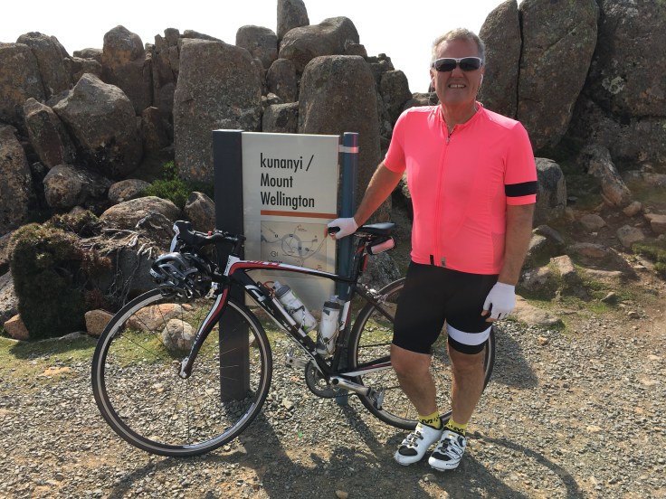
The gradient is still steep – maybe six or seven percent – as I round a series of short bends and see the towers and building of the summit of Mount Wellington. The last five hundred metres is much quicker and I ride – out of the saddle – up towards the car park. I’m there! I’m here! At the summit of Mount Wellington and I’ve made it. Another big mountain ride! And all seemingly worth it – easy to say when you’ve arrived and totally ensconced in the euphoria of having finally arrived. A guy in a bandana walking towards the viewing area sees me and steps a few paces closer. He is cheery, says a quick ‘hi’, says he saw me on the way up and thought it was great that I made it. “Ta,” I say. As I pause, he asks if it was hard. Now this is not an easy question to answer because, firstly, I can’t really speak properly and, secondly, (and I don’t know all of this detail yet, but perhaps understand it experientially…) I’ve just ridden 17.6 kilometres, ascended 1,189 metres at seven percent gradient and it’s taken me one hour, thirty-two minutes and twelve seconds to do so. Was that hard?
 So I mutter, “Ah…not so bad…”. I ride on and, although I’m the only one who knows it, I do a victory lap of the carpark. There’s an amazing view, a staggering backdrop for a serious ride.
Then I realise it is a bit cold up here. Ah, Tasmania…
Afterword – The ‘other rider’, a German exchange student, made it to the top! I caught up with her after my victory lap – in her words, it was “very hard”, particularly when “you don’t ride much and your host family makes you do it”. I can only imagine that she meant, in translation, that her host family strongly encouraged her to give it a go rather than her evening meal (or her bed for the night) was contingent on her riding up Mount Wellington!


Leave a comment